 Site Context - [source code]
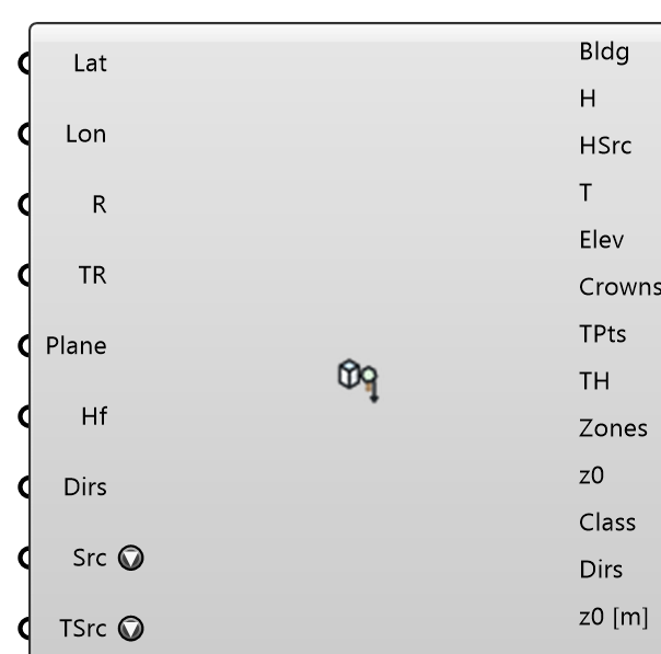
One click from a location to the site's context: buildings with heights, bare-earth terrain, tree crowns, land-cover ground zones with their roughness, and the inlet z0 per wind direction — fetched in the background from open data and placed in a local frame centred on the location (Rhino model units). Sources: OpenStreetMap buildings (ODbL; height from the height tag or building:levels x 3 m, else the Fallback Height — never guessed silently: every building's height KIND is in the report), GEDTM30 bare-earth DTM (CC BY 4.0), the Meta/WRI 1 m canopy height map plus OSM street trees (CC BY 4.0 / ODbL), and ESA WorldCover 2021 (CC BY 4.0). Buildings come from GlobalBuildingAtlas LoD1 (TUM, CC BY-NC 4.0 — heights PREDICTED by a model, every one labelled so) or from OpenStreetMap (ODbL — the height tag or building:levels x 3 m, else the Fallback Height), chosen on Building Source. Results are cached on disk, so a reopened document shows its context without a new fetch; pressing Fetch again, or Refresh from the sources on the right-click menu, downloads anew.
Input
| Name | Nickname | Description | Type |
|---|---|---|---|
| Latitude | Lat | Latitude of the SITE, decimal degrees WGS84. Optional: with neither Latitude nor Longitude wired, the document's Earth Anchor Point is used (and its model point and north become the Anchor). Not an EPW header's latitude — that is the weather station. | Number |
| Longitude | Lon | Longitude of the SITE, decimal degrees WGS84, east positive. Optional, as Latitude. | Number |
| Radius | R | Half-size (m) of the square the buildings, trees and ground zones cover. Buildings straddling the edge are clipped to it. Optional; default 500, at most 3000. | Number |
| Terrain Radius | TR | Half-size (m) of the terrain (and of the ground zones on it). Make it cover the whole CFD domain floor; the inlet z0 is read over the 3 km BEYOND it. Optional; 0 or unset = 2 x Radius. | Number |
| Anchor | Plane | Model plane the location maps to (X = east, Y = north). Optional; default the Earth Anchor Point's plane when the site comes from it, else the world XY origin. | Plane |
| Fallback Height | Hf | Height (m) given to a building whose source states no height or storeys. Such buildings are labelled 'fallback' in the report and on the mesh. 0 = leave them out. Optional; default 9 (three storeys). | Number |
| Wind Directions | Dirs | Wind directions (meteorological degrees, wind FROM, clockwise from north) to report the upstream z0 for. Wire the same list into ABL's Wind Directions. Optional; default the eight compass points. | Number |
| Building Source | Src | Where the buildings come from. Global Building Atlas: LoD1 footprints worldwide with heights PREDICTED by a model (RMSE 1.5-8.9 m; TUM, CC BY-NC 4.0 — non-commercial use), read straight from the published tiles. OpenStreetMap: mapped footprints with the height tag or building:levels x 3 m, else the Fallback Height (ODbL; via the public Overpass mirrors, which can queue for minutes). Overture Maps: the newest release's building footprints (conflated from OpenStreetMap, Microsoft ML Buildings, Esri Community Maps, Google Open Buildings and others), with the height it states or num_floors x 3 m, else the Fallback Height - many buildings carry neither, so check Height Sources (ODbL-1.0 for the theme; the contributing datasets keep their own terms, Esri and Google CC BY 4.0; credit: (c) OpenStreetMap contributors, Overture Maps Foundation), read straight from the published files. The height KIND of every building is on its mesh and in the report. | Text |
| Terrain Source | TSrc | Where the ground comes from. GEDTM30: global bare-earth model, 30 m (CC BY 4.0) - the default. Auto: the regional bare-earth model that covers the site (Canada HRDEM, else USGS 3DEP), else GEDTM30. USGS 3DEP: the 1 m lidar DEM where a project covers the site, else ~10 m, then ~30 m, USA (public domain). Canada HRDEM: lidar DTM at 1 m, then 2 m, where flown, Canada (Open Government Licence - Canada). Copernicus GLO-30: global but a SURFACE model - buildings and trees are in the heights, so building massing seated on it stands too high (use only where nothing else covers the site). Each is read straight from its public bucket, no key. A source with no data at the site gives flat ground and says so in the Report. Optional; default GEDTM30. | Text |
| Fetch | Press to fetch every selected layer in the background — the canvas stays live. One press is one attempt: a Fetch held true by a wired toggle does not retry a failed fetch on every recompute. A press on a site already in the cache downloads it anew (the cached answer stays on the outputs until the new one lands). Right-click to cancel, or to refresh from the sources. | Boolean |
Output
| Name | Nickname | Description | Type |
|---|---|---|---|
| Buildings | Bldg | One closed mesh per building, seated on the terrain (roof = median ground + height; the base reaches 20 m below the lowest ground under it so it pierces the terrain, or stands on z = 0 without terrain). Each mesh carries its height, height kind and source id (OSM or Overture) as user strings. Plug into the wind case's Buildings. | Mesh |
| Building Heights | H | Height (m) above the median ground per building, index-aligned with Buildings. | Number |
| Height Sources | HSrc | Where each height came from, index-aligned with Buildings: predicted (Global Building Atlas), osm:height (a mapped height), osm:levels (storeys x 3 m), overture:height or overture:levels (Overture Maps: stated height, or num_floors x 3 m) or fallback (your Fallback Height). | Text |
| Terrain | T | Bare-earth terrain mesh (GEDTM30), elevation RELATIVE to the ground at the location. Empty when the Terrain layer is off or the DTM host was unreachable (then the report says so and everything stands on flat ground). | Mesh |
| Site Elevation | Elev | Absolute elevation (m above sea level) of the ground at the location — the terrain's z = 0. | Number |
| Tree Crowns | Crowns | Tree crown volumes, one mesh per cluster of the canopy map (4 m columns from 0.41 x tree height to the top) and one per mapped OSM tree the map has no crown over. Plug into the Tree component's Geometry, one Tree per crown. | Mesh |
| Tree Points | TPts | Every mapped OSM tree (natural=tree, and tree_row every 8 m) at its ground point, whether or not it got its own crown. | Point |
| Tree Heights | TH | Height (m) per tree point: the mapped height tag, else 10 m. Index-aligned with Tree Points. | Number |
| Ground Zones | Zones | The terrain split by land use (WorldCover), one mesh per region and class, coloured by z0 on the fixed Davenport scale. Inside Radius the ground is read by the RESOLVED table (built = the street between the meshed buildings, 0.03 m; tree = forest floor under a fetched crown, 0.1 m), beyond it by the upstream one. Wire with Roughness Lengths and Land Cover into Ground Roughness. | Mesh |
| Roughness Lengths | z0 | z0 (m) per ground zone, index-aligned with Ground Zones. | Number |
| Land Cover | Class | Zone name per ground zone (region_class, e.g. core_built, ring_water), index-aligned with Ground Zones — usable as Ground Roughness' Names. | Text |
| Wind Directions | Dirs | The directions z0 per Direction is aligned with. | Number |
| z0 per Direction | z0 [m] | Upstream z0 (m) per wind direction: the log-mean of the land cover over the 3 km the wind crosses before the terrain edge, ±15°. Wire into ABL's z0 per Direction. A sector with no classified land (off the WorldCover map) gets the log-mean of the other directions, with a Warning naming it — never a gap, which would shift every later direction's z0. | Number |
| Report | Origin, as JSON: every source, licence, date, count, what was left out and why, and the building heights by KIND. | Text | |
| Ground Zones | GZones | The land-cover zones as Ground Zone objects (mesh, roughness length z0, name): wire into Outdoor Case's Ground Roughness. Zones itself is plain meshes for display and carries no z0. | Generic Data |